


Col de Côté Plaine

GOHIER
User
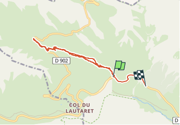

Length
7.2 km

Max alt
2350 m

Uphill gradient
365 m
Km-Effort
12.3 km

Min alt
1904 m

Downhill gradient
439 m
Boucle
No
Creation date :
2023-02-13 10:57:37.0
Updated on :
2023-02-13 13:37:41.63
2h36
Difficulty : Easy

FREE GPS app for hiking
 SityTrail
IGN / Geographical institutes
SityTrail Plus
The world is yours!
About
Trail Touring skiing of 7.2 km to be discovered at Provence-Alpes-Côte d'Azur, Hautes-Alpes, Le Monêtier-les-Bains. This trail is proposed by GOHIER.
Description
Arrêt sur la route du Galibier
Positioning
Country:
France
Region :
Provence-Alpes-Côte d'Azur
Department/Province :
Hautes-Alpes
Municipality :
Le Monêtier-les-Bains
Location:
Unknown
Start:(Dec)
Start:(UTM)
296557 ; 4990964 (32T) N.
Comments